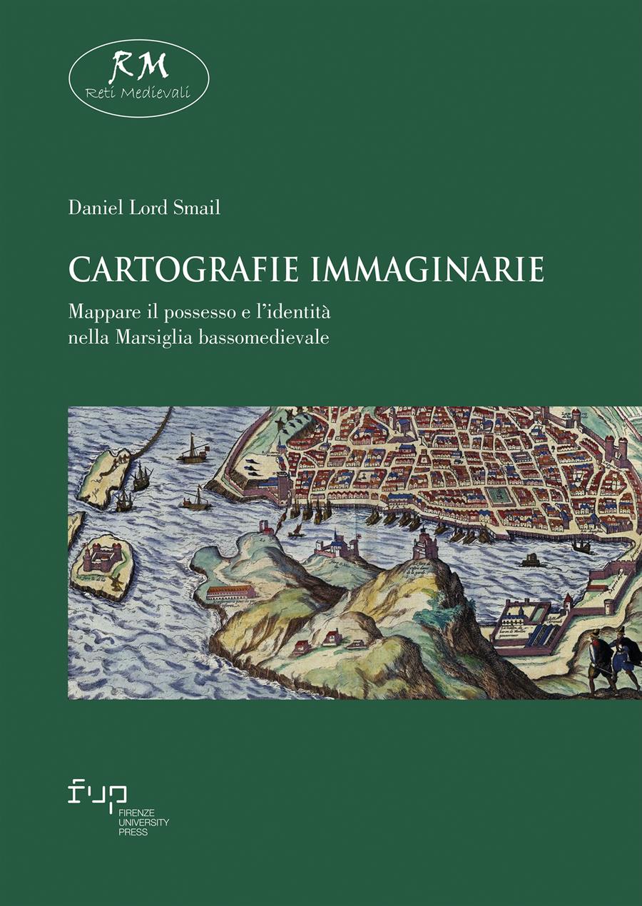
Cartografie immaginarie
Mappare il possesso e l’identità nella Marsiglia bassomedievale
- Daniel Lord Smail,
Come, negli anni precedenti all’avvento delle mappe urbane, i residenti delle città concepivano e si orientavano nello spazio delle loro comunità? Nel suo libro straordinariamente originale, Daniel Lord Smail sviluppa un nuovo metodo e un nuovo vocabolario per comprendere come gli uomini e le donne delle città medievali immaginassero la loro geografia personale. La sua approfondita ricerca nei registri notarili della Marsiglia tardo-medievale lo porta a concludere che gli abitanti mappavano la città, la sua struttura sociale e le loro identità attraverso una serie di grammatiche cartografiche che influenzavano profondamente le loro vite.
Imaginary Cartographies apre potenti nuove vie per esplorare la società urbana tardo-medievale e rinascimentale, producendo una migliore comprensione del ruolo delle percezioni sociali nella storia. Attraverso un metodo serrato di analisi delle fonti scritte notarili, questo libro offre nuove categorie di interpretazione per la storia dello spazio medievale, prima dello sviluppo della cartografia disegnata.
- Parole chiave:
- middle ages,
- history of cartography,
- medieval Marseille,
- landscape history,
- social identities,
- DOI: 10.36253/979-12-215-0606-8
- Collana: Reti Medievali E-Book
- Comitato scientifico
- Lingua: Italiano
- Argomento: Storia
Harvard University, United States - ORCID: 0000-0002-2232-145X
Cartografie immaginarie è la traduzione del suo primo libro, Imaginary Cartographies (Cornell University Press, 1999), che ha vinto il Premio Herbert Baxter Adams dell’American Historical Association e quello della Social Science History Association.
- Abulafia, David. Frederic II. A Medieval Emperor. London: Allen Lane, 1988.
- Abu-Lughod, Janet L. “The Islamic City. Historic Myth, Islamic Essence, and Contemporary Relevance.” International Journal of Middle East Studies, 19 (1987): 155-76.
- Les actes notariés, source de l’histoire sociale, XVIe-XIXe siècles (Actes du colloque de Strasbourg, mai 1978), éd. par Bernard Vogler. Strasbourg: Libraire Istra, 1979.
- Adams, Thomas McStay. Bureaucrats and Beggars: French Social Policy in the Age of the Enlightenment. Oxford: Oxford University Press, 1990.
- Akerman, James R. “The Structuring of Political Territory in Early Printed Atlases.” Imago Mundi 47 (1995): 138-54.
- Alliés, Paul. L’invention du territoire. Grenoble: Presses Universitaires de Grenoble, 1980.
- Amargier, Paul. “Mouvements populaires et confrérie du Saint-Esprit a Marseille au XIIIe siècle.” In La religion populaire en Languedoc du XIIIe siècle a la moitié du XlVe. Cahiers de Fanjeaux, 11, 305-10. Toulouse: Privat, 1976.
- Amelang, James S. “People of the Ribera. Popular Politics and Neighborhood Identity in Early Modern Barcelona.” In Culture and Identity in Early Modern Europe (1500-1800). Essays in Honor of Natalie Zemon Davis, ed. by Barbara Diefendorf, and Carla Hesse, 119-37. Ann Arbor: University of Michigan Press, 1993.
- Anderson, Benedict. “Census, Map, Museum.” In Becoming National. A Reader, ed. by Geoff Eley, and Ronald Grigor Suny, 243-8. New York: Oxford University Press, 1996.
- Anderson, Benedict. Imagined Communities. Reflections on the Origin and Spread of Nationalism. London: Verso, 1983.
- Aubenas, Roger. Étude sur le notariat provençal au moyen âge et sous l’Ancien Régime. Aix-en-Provence: Éditions du Feu, 1931.
- Bagnall, Roger S., Bruce W. Frier. The Demography of Roman Egypt. Cambridge: Cambridge University Press, 1994.
- Baldwin, John W. The Government of Philip Augustus: Foundations of French Royal Power in the Middle Ages. Berkeley: University of California Press, 1986.
- Baratier, Édouard. La démographie provençale du XIIIe au XVIe siècle. Paris: S.E.V.P.E.N., 1961.
- Baratier, Édouard. Histoire de Marseille. Toulouse: Privat 1973.
- Baratier, Édouard, Félix Reynaud. Histoire du commerce de Marseille. II. De 1291 à 1480, sous la direction de Gaston Rambert. Paris: Plon, 1951.
- Barkey, Karen. Bandits and Bureaucrats. The Ottoman Route to State Centralization. Ithaca: Cornell University Press, 1994.
- Barthes, Roland. Empire of Signs, translated by Richard Howard. New York: Hill and Wang, 1982.
- Bartlett, Robert. The Making of Europe: Conquest, Colonization, and Cultural Change, 950-1350. Princeton: Princeton University Press, 1993.
- Bateson, Gregory. Steps to an Ecology of Mind. San Francisco: Chandler Pub. Co., 1972.
- Bautier, Robert-Henri. “Les foires de Champagne. Recherches sur une évolution historique.” In La Foire. Recueils de la société Jean Bodin, 5, 97-147. Brussels: Éditions de la Librairie Encyclopédique, 1953.
- Bautier, Robert-Henri, Janine Sornay. Les sources de l’histoire économique et sociale du moyen âge, I-III. Paris: Centre National de la Recherche Scientifique, 1968-84.
- Beaune, Colette. The Birth of an Ideology: Myths and Symbols of Nation in Late-Medieval France, translated by Susan Ross Huston, ed. by Fredric L. Cheyette. Berkeley: University of California Press, 1991.
- Bellomo, Manlio. The Common Legal Past of Europe, 1000-1800, translated by Lydia G. Cochrane. Washington D.C.: Catholic University of America Press, 1995.
- Bencivenne, Ars notarie, a cura di Giovanni Bronzino. Bologna: Zanichelli 1965.
- Benjamin of Tudela, The Itinerary of Benjamin of Tudela. Travels in the Middle Ages, ed. by Michael A. Signer. Malibu, California: Joseph Simon and Pangloss Press, 1983.
- Benoit, Fernand, et al. Monographies communales, Marseille-Aix-Arles (Les Bouches-du-Rhône. Encyclopedie Departementale, 14/3), sous la direction de Paul Masson. Marseille: Archives Départementales des Bouches-du-Rhône, 1935.
- Berger, Peter L., and Thomas Luckmann. The Social Construction of Reality: A Treatise in the Sociology of Knowledge. Garden City, N.Y.: Doubleday, 1966.
- Berlière, Jean-Marc. Le monde des polices en France, XIXe-XXe siècles. Brussels: Éditions Complexe, 1996.
- Berlow, Rosalind Kent. “The Sailing of the ‘Saint Esprit’.” Journal of Economic History 39 (1979): 345-62.
- Bernardi, Philippe. Métiers du bâtiment et techniques de construction à Aix-en-Provence à la fin de l’époque gothique (1400-1550). Thèse, Université de Provence Aix-Marseille I, 1990.
- Bertillon, Alphonse. Identification anthropométrique. 2 vols. Melun: Typographie-Lithographie Administrative, 1893.
- Biddick, Kathleen. “Paper Jews: Inscription/Ethnicity/Ethnography.” Art Bulletin 78 (1996): 594-9.
- Bisson, Thomas N. “The ‘Feudal Revolution’. Past and Present 142 (1994): 6-42.
- Black, Jeremy. Maps and Politics. London: Reaktion Books Ltd, 1997.
- Blancard, Louis. Documents inédits sur le commerce de Marseille au moyen âge, édités intégralement ou analysés. 2 vols. Genève: Mégariotis Reprints, 1978 [1884].
- Blès, Adrien. Dictionnaire historique des rues de Marseille. Marseille: Éditions Jeanne Laffitte, 1989.
- Boltanski, Luc. Les cadres. La formation d’un groupe social. Paris: Minuit, 1982.
- Bouiron, Marc. “Le fond du Vieux-Port à Marseille, des marécages à la place Général-de-Gaulle.” Mediterranée 3 (1995): 65-8.
- Bourrilly, Victor-Louis. Essai sur l’histoire politique de Marseille des origines à 1264. Aix-en-Provence: A. Dragon, 1925.
- Boutier, Jean, Alain Dewerpe, et Daniel Nordman. Un tour de France royal. Le voyage de Charles IX (1564-1566). Paris: Éditions Aubier Montaigne, 1984.
- Broise, Henri. “Les maisons d’habitation à Rome aux XVe et XVIe siècles.” In D’une ville à l’autre. Structures matérielles et organisation de l’éspace dans les villes européennes (XIIIe-XVIe siècle). Collection de l’École française de Rome, 122, 609-29. Rome: École française de Rome, 1989.
- Broise, Henri, e Jean-Claude Maire Vigueur. Strutture familiari, spazio domestico e architettura civile a Roma alla fine del medioevo, in Storia dell'arte italiana, 12, Momenti di architettura, 99-160. Torino: Einaudi, 1983.
- Brown, Lloyd A. The Story of Maps. Boston: Little, Brown, 1949.
- Burke, Peter. The Historical Anthropology of Early Modern Italy: Essays on Perception and Communication. Cambridge: Cambridge University Press, 1987.
- Burroughs, Charles. “Spaces of Arbitration.” In Medieval Practices of Space, ed. by Barbara Hanawalt, and Michal Kobialka. Minneapolis: University of Minnesota Press, 2000.
- Busino, Giovanni. Les théories de la bureaucratie. Paris: Presses Universitaires de France, 1993.
- Busquet, Raoul. Histoire de Marseille, mise à jour de Pierre Guiral. Paris: Éditions Robert Laffont, 1978.
- Busquet, Raoul. “L’organisation de la justice à Marseille au moyen âge.” Provincia 2 (1922): 1-15.
- Cambridge Economic History, 2d ed., 3 vols. Ed. by Michael M. Postan, and Edward Miller. Cambridge: Cambridge University Press, 1987.
- Carruthers, Mary. The Book of Memory: The Study of Memory in Medieval Culture. Cambridge: Cambridge University Press, 1990.
- Cartography in the Traditional Islamic and South Asian Societies. Vol. 2 of The History of Cartography, ed. by J. Brian Harley, and David Woodward, 464-501. Chicago: University of Chicago Press, 1987.
- Cassirer, Ernst. The Myth of the State. New Haven: Yale University Press, 1946.
- Chiffoleau, Jacques. La comptabilité de l’au-delà: les hommes, la mort et la religion dans la région d’Avignon au quatorzième siècle. Rome: École Francaise de Rome, 1980.
- Clanchy, Michael T. From Memory to Written Record: England, 1066-1307, 2nd ed. London: Blackwell, 1993 [1979].
- Cohn, Bernard S., and Nicholas B. Dirks. “Beyond the Fringe: The Nation State, Colonialism, and the Technologies of Power.” Journal of Historical Sociology 1 (1988): 224-9.
- Cohn, Samuel Kline, Jr. Death and Property in Siena, 1205-1800. Baltimore: Johns Hopkins University Press, 1988.
- Cohn, Samuel Kline, Jr. The Laboring Classes in Renaissance Florence. New York: Academic Press, 1980.
- Coulet, Noel. Aix-en-Provence. Éspace et relations d’une capitale (milieu XIVe siècle - milieu XVe siècle). 2 vols. Aix-en-Provence: Université de Provence, 1988.
- Coulet, Noel. “Quartiers et communauté urbaine en Provence (XIIIe-XVe siècles)." In Villes, bonnes villes, cités et capitales. Études d’histoire urbaine (XIIe-XVIIIe siècle) offertes à Bernard Chevalier, textes réunis par Monique Bourin, 351-9. Tours: Université de Tours, 1989.
- Couton, Georges, et Henri-Jean Martin. “Une source d’histoire sociale: le registre de l’état d’âmes.” Revue d’histoire économique et sociale 45 (1967): 244--53.
- Crozier, Michael. Le phénomène bureaucratique. Paris: Seuil, 1963.
- Cultures of Power. Lordship, Status, and Process in Twelfth-Century Europe, ed. by Thomas N. Bisson. Philadelphia: University of Pennsylvania Press, 1995.
- Dauzat, Albert. Dictionnaire étymologique des noms de familles et prénoms de France. Paris: Larousse, 1951.
- Designation et anthroponymie des femmes. Méthodes statistiques pour l’anthroponymie, in Genèse médiévale de l'anthroponymie moderne, vol. II-2, études reunis par Monique Bourin et Pascal Chareille. Tours: Publications de l'Université de Tours, 1992.
- Diamond, Jared M. Collapse: How Societies Choose to Fail or Succeed. New York: Viking, 2005.
- Dilke, Oswald A. W. Greek and Roman Maps. Ithaca: Cornell University Press, 1985.
- Directions in Sociolinguistics. The Ethnography of Communication, ed. by John J. Gumperz, and Dell Hymes. New York: Holt, Rinehart and Winston, 1972.
- Douglas, Mary. How Institutions Think. Syracuse: Syracuse University Press, 1986.
- Drendel, John. “Notarial Practice in Rural Provence in the Early Fourteenth Century.” In Urban and Rural Communities in Medieval France: Provence and Languedoc, 1000-1500, ed. by Kathryn L. Reyerson, and John Drendel, 209-35. Leiden: Brill, 1998.
- Droguet, Main. Administration financière et système fiscal à Marseille dans la seconde moitié du XIVe siècle. Aix-en-Provence: Centre d’ Études des Sociétés Méditerranéennes, 1983.
- Duby, Georges. The Chivalrous Society, translated by Cynthia Postan. Berkeley: University of California Press, 1977.
- Du Cange, Charles Du Fresne. Glossarium mediae et infimae latinitatis. Paris: Firmin Didot Fratres, 1842.
- Dupanloup, Marc. “La corporation des cuiratiers à Marseille dans la première moitié du XIVe siècle.” Provence historique 77 (1969): 189-213.
- Eckstein, Nicholas A. The District of the Green Dragon. Neighbourhood Life and Social Change in Renaissance Florence. Florence: Leo S. Olschki Editore, 1995.
- Edgerton, Samuel Y., Jr. The Renaissance Rediscovery of Linear Perspective. New York: Basic Books, 1975.
- Eisenstein, Elizabeth. The Printing Press as an Agent of Change. Communications and Cultural Transformations in Early Modern Europe. 2 vols. Cambridge: Cambridge University Press, 1979.
- Emery, Richard W. The Jews of Perpignan in the Thirteenth Century. An Economic Study Based on Notarial Records. New York: Columbia University Press, 1959.
- Emery, Richard W. “The Use of the Surname in the Study of Medieval Economic History.” Medievalia et Humanistica o.s. 7 (1952): 43-50.
- L’enquête sur les catégories: de Durkheim à Sacks. Raisons Pratiques, 5. Paris: École des Hautes Études en Sciences Sociales, 1994.
- Explorations in the Ethnography of Speaking, ed. by Richard Bauman, and Joel Sherzer, 2d ed. Cambridge: Cambridge University Press, 1989 [1974].
- Fabre, Augustin. Notice historique sur les anciennes rues de Marseille, démolies en 1862 pour la création de la rue Impériale. Marseille: Jules Barile, 1862.
- Fabre, Augustin. Les rues de Marseille. I-V. Marseille: E. Camoin, 1867-9.
- Fabre, Ghislaine, Thierry Lochard. Montpellier: la ville médiévale. Paris: Imprimerie Nationale, 1992.
- Fawtier, Robert. “Comment le roi de France, au début du XIVe siècle, pouvait-il se représenter son royaume?” In Mélanges offerts à M. Paul-E. Martin par ses amis, ses collègues, ses élèves. Mémoires et documents publiés par la societé d’histoire et d’archeologie de Genève, 40, 65-77. Genève: La Société d’Histoire et d’Archeologie de Genève, 1961.
- Fentress, James, and Chris Wickham. Social Memory. Oxford: Blackwell, 1992.
- Février, Paul-Albert. Le développement urbain en Provence de l’époque romaine a la fin du XIVe siècle. Paris: Éditions E. de Boccard, 1964.
- Five Centuries of Map Printing, ed. by David Woodward. Chicago: University of Chicago Press, 1975.
- Fortifications, portes de villes, places publiques, dans le monde mediterranéen, a cura di Jacques Heers. Paris: Presses de l’Université de Paris-Sorbonne, 1985.
- Foucault, Michel. Madness and Civilization: A History of Insanity in the Age of Reason, translated by Richard Howard. New York: Vintage Books, 1965.
- Foucault, Michel. Power/Knowledge. Selected Interviews and Other Writings, 1972-77, translated by Colin Gordon, ed. by Colin Gordon et al. New York: Pantheon Books, 1980.
- Frangenberg, Thomas. “Chorographies of Florence. The Use of City Views and City Plans in the Sixteenth Century.” Imago Mundi 46 (1994): 41-64.
- Frugoni, Chiara. A Distant City. Images of Urban Experience in the Medieval World, translated by William McCuaig. Princeton: Princeton University Press, 1991.
- Frugoni, Chiara. Una lontana città: sentimenti e immagini nel Medioevo. Torino: Einaudi, 1983.
- Garrioch, David. “House Names, Shop Signs and Social Organization in Western European Cities, 1500-1900.” Urban History 21 (1994): 20-48.
- Geary, Patrick J. Phantoms of Remembrance. Memory and Oblivion at the End of the First Millennium. Princeton: Princeton University Press, 1995.
- Geremek, Bronisław. The Margins of Society in Late Medieval Paris, translated by Jean Birrell. Cambridge: Cambridge University Press, 1987.
- Ginzburg, Carlo. “Clues: Roots of a Evidential Paradigm.” In C. Ginzburg, Clues, Myth, and Historical Method, translated by John Tedeschi, and Anne C. Tedeschi, 96-125. Baltimore: Johns Hopkins University Press, 1989.
- Goitein, Shlomo Dov. A Mediterranean Society: The Jewish Community of the Arab World as Portrayed in the Documents of the Cairo Geniza. 5 vols. Berkeley: University of California Press, 1967.
- Goody, Jack. The Interface between the Written and the Oral. Cambridge: Cambridge University Press, 1987.
- Goody, Jack. The Logic of Writing and the Organization of Society. Cambridge: Cambridge University Press, 1986.
- Gould Stephen Jay. Wonderful Life: The Burgess Shale and the Nature of History. New York: W.W. Norton, 1989.
- Gouron, André. La réglementation des métiers en Languedoc au moyen âge. Genève: 1958.
- Guenée, Bernard. “La géographie administrative de la France à la fin du moyen âge: élections et bailliages.” Le moyen âge 67 (1961): 293-323.
- Gumperz, John J. “The Speech Community.” In Language and Social Context, ed. by Pier Paolo Giglioli, 219-31. Harmondsworth: Penguin, 1971.
- Hacking, Ian. “Making Up People.” In Reconstructing Individualism: Autonomy, Individuality, and the Self in Western Thought, ed. by Thomas C. Heller, Morton Sosna, and David W. Wellbery, 222-36. Stanford: Stanford University Press, 1986.
- Halbwachs, Maurice. On Collective Memory, ed. and translated by Lewis A. Coser. Chicago: University of Chicago Press, 1992.
- Hallam, Elizabeth. Capetian France, 987-1328. London: Longman, 1980.
- Hardwick, Julie. The Practice of Patriarchy: Gender and the Politics of Household Authority in Early Modern France. University Park: Pennsylvania State University Press, 1998.
- Harley, J. Brian. “Maps, Knowledge and Power.” In The Iconography of Landscape. Essays on the Symbolic Representation, Design, and Use of Past Environments, ed. by Denis Cosgrove, and Stephen Daniels, 277-12. Cambridge: Cambridge University Press, 1988.
- Harley, J. Brian. “Silences and Secrecy. The Hidden Agenda of Cartography in Early Modern Europe.” Imago Mundi 40 (1988): 57-76.
- Harvey, Paul D.A. The History of Topographical Maps: Symbols, Pictures and Surveys. London: Thames and Hudson, 1980.
- Harvey, Paul D.A. “Local and Regional Cartography in Medieval Europe.” In Cartography in Prehistoric, Ancient, and Medieval Europe and the Mediterranean. Vol. 1 of The History of Cartography, ed. by J. Brian Harley, and David Woodward, 464-501. Chicago: University of Chicago Press, 1987.
- Harvey, Paul D.A., Maps in Tudor England. Chicago: University of Chicago Press, 1993.
- Hébert, Michel. Tarascon au XVe siècle. Histoire d’une communauté urbaine provençale. Aix-en-Provence: Edisud, 1979.
- Heers, Jacques. Espaces publics, espaces privés dans la ville. Le liber terminorum de Bologne (1294). Paris: CNRS, 1984.
- Heers, Jacques. Family Clans in the Middle Ages: A Study of Political and Social Structures in Urban Areas, translated by Barry Herbert. Amsterdam: North-Holland Publishing, 1977.
- Heers, Jacques. La ville au moyen âge en Occident. Paris: Fayard, 1990.
- Helgerson, Richard. “The Land Speaks. Cartography, Chorography, and Subversion in Renaissance England.” Representations 16 (1986): 50-85.
- Herlihy, David. Medieval and Renaissance Pistoia. The Social History of an Italian Town, 1200-1430. New Haven: Yale University Press, 1967.
- Herlihy, David. Medieval Households. Cambridge, Mass.: Harvard University Press, 1985.
- Herlihy, David. Pisa in the Early Renaissance: A Study of Urban Growth. New Haven: Yale University Press, 1958.
- Herlihy, David. “Problems of Record Linkages in Tuscan Fiscal Records of the Fifteenth Century.” In Identifying People in the Past, ed. by Edward A. Wrigley, 41-56. London: Edward Arnold, 1973.
- Herlihy, David, et Christiane Klapisch-Zuber. Les toscans et leurs familles: une étude du catasto florentin de 1427. Paris: Ecole des Hautes Études en Sciences Sociales, 1978.
- Herzfeld, Michael T. The Social Production of Indifference. Chicago: University of Chicago Press, 1992.
- Histoire du commerce de Marseille. I-VII. [Chambre de Commerce de Marseille], sous la direction de Gaston Rambert. Paris: Plon, 1949-66.
- The History of Cartography, 2 vols., ed. by J. Brian Harley, David Woodward. Chicago: University of Chicago Press, 1987.
- Hsiao, Kung-Chuan. Rural China: Imperial Control in the Nineteenth Century. Seattle: University of Washington Press, 1960.
- Hsü, Immanuel C.Y. The Rise of Modern China. New York: Oxford University Press, 1970.
- Hsu, Mei-Ling. “An Inquiry into Early Chinese Atlases through the Ming Dynasty.” In Images of the World: The Atlas through History, ed. by John A. Wolter, and Ronald E. Grim. Washington D.C.: McGraw-Hill, 1997.
- Hughes, Diane Owen. “Toward Historical Ethnography. Notarial Records and Family History in the Middle Ages.” Historical Methods Newsletter 7 (1974): 61-71.
- Huizinga, Johan. The Autumn of the Middle Ages, translated by Rodney J. Payton, and Ulrich Mammitzsch. Chicago: University of Chicago Press, 1996.
- The Invention of Tradition, ed. by Eric Hobsbawn, and Terence Ranger. Cambridge: Cambridge University Press, 1983.
- Jones, Arnold H.M. The Roman Economy. Studies in Ancient Economic and Administrative
- History, ed. by Peter A. Brunt. Totowa, N.J.: Rowman and Littlefield, 1974.
- Jones, Norman L. “William Cecil and the Making of Economic Policy in the 1560s and early 1570s.” In Political Thought and the Tudor Commonwealth. Deep Structure, Discourse and Disguise, ed. by Paul A. Fideler, and T. F. Mayer. London: Routledge, 1992.
- Jordan, William Chester. Women and Credit in Pre-Industrial and Developing Societies. Philadelphia: University of Pennsylvania Press, 1993.
- Judische Urkundenformulare aus Marseille in babylonisch-aramaischer Sprache, hg. von Hans-Georg von Mutius. Judentum and Umwelt, 50. Frankfurt: Peter Lang, 1994.
- Kain, Roger J.P., and Elizabeth Baigent. The Cadastral Map in the Service of the State. Chicago: University of Chicago Press, 1992.
- Keene, Derek. Survey of Medieval Winchester. 2 vols. Oxford: Clarendon Press, 1985.
- Keene, Derek, and Vanessa Harding. A Survey of Documentary Sources for Property Holding in London before the Great Fire. London: London Record Society, 1985.
- Kent, Dale V. The Rise of the Medici. Faction in Florence, 1426-1434. Oxford: Oxford University Press, 1978.
- Kent, Dale V., and Francis William Kent. Neighbours and Neighbourhood in Renaissance Florence. The District of the Red Lion in the Fifteenth Century. Locust Valley, N.Y.: J. J. Augustin, 1982.
- Kent, F.W. Household and Lineage in Renaissance Florence: The Family Life of the Capponi, Ginori and Rucellai. Princeton: Princeton University Press, 1977.
- Kirshner, Julius. “Civitas Sibi Faciat Civem: Bartolus of Sassoferrato’s Doctrine on the Making of a Citizen.” Speculum 48 (1973): 694-713.
- Kirshner, Julius. “A Consilium of Rosello dei Roselli on the Meaning of ‘Florentinus,’ ‘de Florentia’ and ‘de populo’.” Bulletin of Medieval Canon Law n.s., 6 (1976): 87-91.
- Klapisch-Zuber, Christiane. Women, Family, and Ritual in Renaissance Italy, translated by Lydia G. Cochrane. Chicago: University of Chicago Press, 1985.
- Konvitz, Josef. Cartography in France, 1660-1848. Science, Engineering, and Statecraft. Chicago: University of Chicago Press, 1993.
- Kuehn, Thomas J. Emancipation in Late Medieval Florence. New Brunswick, N.J.: Rutgers University Press, 1982.
- Kuehn, Thomas J. Law, Family, and Women: Toward a Legal Anthropology of Renaissance Italy. Chicago: University of Chicago Press, 1991.
- Labov, William. Sociolinguistic Patterns. Philadelphia: University of Pennsylvania Press, 1972.
- Lakoff, George. Women, Fire, and Dangerous Things. What Categories Reveal about the Mind. Chicago: University of Chicago Press, 1987.
- Lakoff, George, Mark Johnson. Metaphors We Live By. Chicago: University of Chicago Press, 1980.
- Lane, Frederick C. “The Enlargement of the Great Council of Venice.” In Florilegium Historiale: Essays Presented to Wallace K. Ferguson, ed. by John G. Rowe, and W.H. Stockdale, 237-74. Toronto: University of Toronto Press, 1971.
- Language and Social Context, ed. by Pier Paolo Giglioli. Harmondsworth: Penguin, 1971.
- Language and Space, ed. by Paul Bloom et al., Cambridge, Mass.: MIT Press, 1996.
- Latouche, Robert. “Étude sur le notariat dans le comté de Nice pendant le moyen âge.” Le moyen âge 37 (1927): 129-69.
- Lavedan, Pierre. Histoire de l’urbanisme: renaissance et temps modernes, 2nd ed. Paris: Henri Laurens, 1959.
- Lavedan, Pierre. Représentations des villes dans l’art du moyen âge. Paris: Vanoest, 1954.
- Leguay, Jean-Pierre. La rue au moyen âge. Rennes: Ouest-France, 1984.
- Leonard, Émile-G. Histoire de Jeanne Ière, reine de Naples, comtesse de Provence (1343-1382), 3 voll., Monaco: Imprimerie de Monaco, 1932.
- Lesage, Georges. Marseille angevine. Recherches sur son évolution administrative, économique et urbaine de la victoire de Charles d’Anjou à l'arrivée de Jeanne Ière (1264-1348), Paris: Boccard, 1950.
- Lestocquoy, Jean. Aux origines de la bourgeoisie: les villes de Flandre et d’Italie sous le gouvernement des patriciens (XIe-XVe siècles). Paris: Presses Universitaires de France, 1952.
- Lopez, Robert S. The Commercial Revolution of the Middle Ages, 950-1350. Englewood Cliffs, N.J.: Prentice-Hall, 1971.
- Lopez, Robert S. “Concerning Surnames and Places of Origin.” Medievalia et Humanistica o.s., 8 (1954): 6-16.
- Mabilly, Philippe. Les villes de Marseille au moyen âge. Ville supérieure et ville de la prévôté. Marseille: Astier, 1905.
- Malaussena, P.L. La vie en Provence orientale aux XIVe et XVe siècles. Un exemple: Grasse à travers les actes notariés. Paris: Librarie Generale du Droit et Jurisprudence, 1969.
- Mapping medieval geographies. Geographical encounters in the Latin West and beyond, 300-1600, ed. by Keith D. Lilley. Cambridge: Cambridge University Press, 2013.
- Maps of Authority: Conflict in the Medieval and Early Modern Urban Landscape. Special number of the Journal of Medieval and Early Modern Studies 26 (1996).
- Marseille et ses rois de Naples: la diagonale angevine, 1265-1382. Aix-en-Provence: Edisud, 1988.
- Martines, Lauro. Lawyers and Statecraft in Renaissance Florence. Princeton: Princeton University Press, 1968.
- Matthews, C. M. English Surnames. New York: Charles Scribner’s Sons, 1966.
- Maurel, Christian. “Le prince et la cité. Marseille et ses rois . . . de Naples (fin XIIIe-fin XIVe siècles).” In Marseille et ses rois de Naples, la diagonale angevine, 1265-1382, 91-8. Aix-en-Provence: Edisud, 1988.
- Maurel, Christian. “Structures familiales et solidarités lignagères à Marseille au XVe siècle. Autour de l’ascension sociale des Forbin.” Annales ESC 41 (1986): 657-81.
- McKitterick, Rosamond. The Carolingians and the Written Word. Cambridge: Cambridge University Press, 1989.
- Miller, Naomi. “Mapping the City: Ptolemy’s Geography in the Renaissance.” In Envisioning the City. Six Studies in Urban Cartography, ed. by David Buisseret, 34-74. Chicago: University of Chicago Press, 1998.
- Miller, William Ian. Bloodtaking and Peacemaking. Feud, Law, and Society in Saga Iceland. Chicago: University of Chicago Press, 1990.
- Monarchs, Ministers and Maps. The Emergence of Cartography as a Tool of Government in Early Modern Europe, ed. by David Buisseret. Chicago: University of Chicago Press, 1992.
- Montorzi, Mario. ‘Fides in rem publicam’: ambiguità e tecniche del diritto comune. Napoli: Casa Editrice Jovene, 1984.
- Moore, R.I. The Formation of a Persecuting Society. Power and Deviance in Western Europe, 950-1250. New York: Basil Blackwell, 1987.
- Mousnier, Roland. The Institutions of France under the Absolute Monarchy, 1598-1789, translated by Brian Pearce. Chicago: University of Chicago Press, 1979.
- Nicolet, Claude. Space, Geography, and Politics in the Early Roman Empire, translated by Helène Leclerc. Ann Arbor: University of Michigan Press, 1991.
- Noble, Thomas F.X. “Literacy and the Papal Government in Late Antiquity and the Early Middle Ages.” In The Uses of Literacy in Early Mediaeval Europe, ed. by Rosamond McKitterick, 82-108. Cambridge: Cambridge University Press, 1990.
- Noiriel, Gérard. Le creuset français. Histoire de l’immigration XIXe-XXe siecles. Paris: Seuil, 1988.
- Noiriel, Gérard. La tyrannie du nation. Le droit d’asile en Europe 1793-1993. Paris: CalmannLevy, 1991.
- Norman, E. Herbert. Origins of the Modern Japanese State, ed. by John W. Dower. New York: Pantheon Books, 1975.
- Il notaio nella civiltà fiorentina, secoli XIII-XVI, mostra alla Biblioteca Medicea Laurenziana (Firenze, 1 Ottobre - 10 Novembre 1984). Firenze: Vallecchi, 1984.
- Notaires, notariat et société sous l’ancien régime. Actes du colloque de Toulouse, 15 et 16 décembre 1989, éd. par Jean-Louis Laffont, Toulouse: Presses Universitaires du Mirail, 1990.
- Le notariat en Roman Pays de Brabant et l’enseignement du notariat à l’Université catholique de Louvain (Catalogue de l’Exposition organisée à Louvain-la-Neuve du 13 au 28 mars 1986), ed. par Philippe Godding. Bruxelles: Archives générales du Royaume, 1986.
- The Origins of the State in Italy, 1300-1600, ed. by Julius Kirshner. Chicago: University of Chicago Press, 1995.
- Otis, Leah Lydia. Prostitution in Medieval Society: The History of an Urban Institution in Languedoc. Chicago: University of Chicago Press, 1985.
- Pansier, Pierre. Histoire de la langue provençale à Avignon du 12e au 19e siècle. Genève: Slatkine Reprints, 1974 [1 ed. 1924].
- Pernoud, Régine. Essai sur l’histoire du port de Marseille des origines à la fin du XIIIe siècle. Marseille: A. Ged, 1935.
- Petrucci, Armando. “Pouvoir de l’écriture, pouvoir sur l’écriture dans la renaissance italienne.” Annales ESC 43 (1988): 823-47.
- Petrucci, Armando. Writers and Readers in Medieval Italy: Studies in the History of Written Culture, ed. and translated by Charles M. Radding. New Haven: Yale University Press, 1995.
- Pick, Shlomo H. The Jewish Communities of Provence before the Expulsion in 1306. Ph.D. dissertation, Bar-Ilan University, 1996.
- Pinker, Steven. How the Mind Works. New York: W. W. Norton and Co., 1997.
- Pinto, John A. “Origins and Development of the Ichnographic City Plan.” Society of Architectural Historians Journal 35 (1976): 35-50.
- Platt, Colin. Medieval Southampton. The Port and Trading Community, A.D. 1000-1600. London: Routledge and Kegan Paul, 1973.
- Plesner, Johan. L’émigration de la campagne à la ville libre de Florence au XIIIe siècle, translated by Françoise Gleizal. Copenhagen: Gyldendal, 1934.
- Poisson, Jean-Paul. Études notariales. Paris: Economica, 1996.
- Poisson, Jean-Paul. Notaires et société. Travaux d’histoire et de sociologie notariales. 2 vols. Paris: Economica, 1985-90.
- Poos, Lawrence R. A Rural Society after the Black Death: Essex, 1350-1525. Cambridge: Cambridge University Press, 1991.
- Pringle, James Keith. The Quiet Conflict. Landlord and Merchant in the Planning of Marseille, 1750-1820. Ph.D. dissertation, Johns Hopkins University, 1984.
- Pryor, John. Business Contracts of Medieval Provence. Selected “Notulae” from the Cartulary of Giraud Amalric of Marseilles, 1248. Toronto: Pontifical Institute of Mediaeval Studies, 1981.
- Raeff, Marc. The Well-Ordered Police State. Social and Institutional Change through Law in the Germanies. New Haven: Yale University Press, 1983.
- Raftis, J. Ambrose. Tenure and Mobility. Studies in the Social History of the Mediaeval English Village. Toronto: Pontifical Institute of Mediaeval Studies, 1964.
- Rau, Susanne, History, space, and place. London-New York: Routledge, 2019.
- Reader in Bureaucracy, ed. by Robert K. Merton et al. New York: Free Press, 1952.
- Realms of Memory. Rethinking the French Past, ed. by Pierre Nora, translated by Arthur Goldhammer. New York: Columbia University Press, 1996.
- Reyerson, Kathryn L. Business, Banking and Finance in Medieval Montpellier. Toronto: Pontifical Institute of Mediaeval Studies, 1985.
- Reyerson, Kathryn L. “Land, Houses and Real Estate Investment in Montpellier: A Study of the Notarial Property Transactions, 1293-1348.” Studies in Medieval and Renaissance History 6 (1983): 39-112.
- Reyerson, Kathryn L. Society, Law, and Trade in Medieval Montpellier. Aldershot: Variorum, 1995.
- Rice, Sally. “Prepositional Prototypes.” In The Construal of Space in Language and Thought, ed. by Martin Pütz, and René Dirven. Berlin: Mouton de Gruyter, 1996.
- Richerson Peter J., and Robert Boyd. Not by Genes Alone: How Culture Transformed Human Evolution. Chicago: University of Chicago Press, 2005.
- Riesenberg, Peter. Citizenship in the Western Tradition. Plato to Rousseau. Chapel Hill: University of North Carolina Press, 1992.
- Romaine, Suzanne. Socio-Historical Linguistics. Its Status and Methodology. Cambridge: Cambridge University Press, 1982.
- Romano, Dennis. Patricians and Popolani. The Social Foundations of the Venetian Renaissance State. Baltimore: Johns Hopkins University Press, 1987.
- Rossiaud, Jacques. Medieval Prostitution, translated by Lydia G. Cochrane. New York: Basil Blackwell, 1988.
- Ruffi, Antoine. Histoire de la ville de Marseille. Marseille: Claude Garcin, 1642.
- Sacks, Harvey. Lectures on Conversation. 2 vols, ed. by Gail Jefferson. Oxford: Blackwell, 1992.
- Sahlins, Peter. Boundaries. The Making of France and Spain in the Pyrenees. Berkeley: University of California Press, 1989.
- Salatiele. Ars notarie, a cura di Gianfranco Orlandelli. Milano: Giuffrè, 1961.
- Schmid, Karl. Gebetsgedenken and adliges Selbstverständnis im Mittelalter. Sigmaringen: Jan Thorbecke Verlag, 1983.
- Schmieder, Felicitas. “Mapping Frankfurt c. 1350: Baldemar of Petterweil’s Recording of Space in Medieval Urban-Ecclesiastical Sources Space in Medieval Urban-Ecclesiastica.” Peregrinations: Journal of Medieval Art and Architecture 7 (2021): 54-72.
- Schneider, Jean. “Problèmes d’histoire urbaine dans la France médiévale.” In Tendances, perspectives et méthodes de l’histoire médiévale, actes du 100e congrès national des sociétés savantes (Paris, 1975), I, Section de philologie et d’histoire jusqu’à 1610, 137-62. Paris: Bibliothèque Nationale, 1977.
- Schulz, Juergen. “Iacopo de’ Barbari’s View of Venice. Map Making, City Views, and Moralized Geography before the Year 1500.” Art Bulletin 6o (1978): 425-74.
- Scott, James C. Seeing Like a State. How Certain Schemes to Improve the Human Condition Have Failed. New Haven: Yale University Press, 1998.
- The Settlement of Disputes in Early Medieval Europe, ed. by Wendy Davies, and Paul Fouracre. Cambridge: Cambridge University Press, 1986.
- Shatzmiller, Joseph R. Shylock Reconsidered. Jews, Moneylending, and Medieval Society. Berkeley: University of California Press, 1990.
- Silberman, Bernard S. Cages of Reason. The Rise of the Rational State in France, Japan, the United States, and Great Britain. Chicago: University of Chicago Press, 1993.
- Sivéry, Gérard. “La déscription du royaume de France par les conseillers de Philippe Auguste et par leurs successeurs.” Le moyen âge 90 (1984): 65-85.
- Skelton, Raleigh Ashlin. Maps: A Historical Survey of Their Study and Collecting. Chicago: University of Chicago Press, 1972.
- Smail, Daniel Lord. “Accommodating Plague in Medieval Marseille.” Continuity and Change 11 (1996): 11-41.
- Smail, Daniel Lord. “Los archivos de conocimiento y la cultura legal de la publicidad en la Marsella medieval.” Hispania: revista espanola de historia 57 (1997): 1049-77.
- Smail, Daniel Lord. “Common Violence: Vengeance and Inquisition in Fourteenth-Century Marseille,” Past and Present 151 (1996): 28-59.
- Smail, Daniel Lord. “Démanteler le patrimoine. Les femmes et les biens dans la Marseille médiévale.” Annales ESC 52 (1997): 343-68.
- Smail, Daniel Lord. “Faction and Feud in Fourteenth-Century Marseille.” In Feud in Medieval and Early Modern Europe, ed. by Jeppe Büchert Netterstrøm, and Bjørn Poulsen, 113-34. Aarhus: Aarhus University Press, 2007.
- Smail, Daniel Lord. “The General Taille of Marseille, 1360-1361. A Social and Demographic Study.” Provence historique 49 (1999): 473-85.
- Smail, Daniel Lord. “Mapping Networks and Knowledge in Medieval Marseille. Variations on a Theme of Mobility.” Ph.D. dissertation, University of Michigan, 1994.
- Smail, Daniel Lord. “Notaries, Courts, and the Legal Culture of Late Medieval Marseille.” In Urban and Rural Communities in Medieval France: Provence and Languedoc, 1000-1500, ed. by Kathryn L. Reyerson, and John Drendel, 23-50. Leiden: Brill, 1998.
- Smail, Daniel Lord. “Pattern in History.” KNOW: A Journal on the Formation of Knowledge 1, no. 1 (March 1, 2017): 155-69.
- Smail, Daniel Lord. “Telling Tales in Angevin Courts.” French Historical Studies 20 (1997): 183-215.
- Smail, Daniel Lord. “La topographie socioprofessionnelle de Marseille au XIVe siècle.” In Marseille. Trames et paysages urbains de Gyptis au Roi René, ed. Marc Bouiron, et Henri Tréziny. Études massaliètes, 7, 307-16. Aix-en-Provence: Edisud, 2001.
- Smail, Daniel Lord. “The Two Synagogues of Medieval Marseille: Documentary Evidence.” Revue des études juives 154 (1995): 115-24.
- The Social History of Language, ed. by Peter Burke, and Roy Porter, Cambridge: Cambridge University Press, 1987.
- Sources of Social History. Private Acts of the Late Middle Ages, ed. by Paolo Brezzi, and Egmont Lee. Toronto: Pontifical Institute of Mediaeval Studies, 1980.
- The spatial turn. Interdisciplinary perspectives, ed. by Barney Warf, and Santa Arias. London: Routledge, 2008.
- Spiegel, Gabrielle M. Romancing the Past: The Rise of Vernacular Prose Historiography in Thirteenth-Century France. Berkeley: University of California Press, 1993.
- Spilner, Paula Lois. “Ut Civitas Amplietur”. Studies in Florentine Urban Development, 1282-1400. Ph.D. dissertation, Columbia University, 1987.
- Stock, Brian. The Implications of Literacy: Written Language and Models of Interpretation in the Eleventh and Twelfth Centuries. Princeton: Princeton University Press, 1983.
- Stouff, Louis. “Arles à la fin du moyen âge. Paysage urbain et géographie sociale.” In Le paysage urbain au moyen âge, Actes du XIe Congrès des historiens médiévistes de l’enseignement supérieur, 225-51. Lyon: Presses Universitaires de Lyon, 1981.
- Stouff, Louis. “La population d’Arles au XVe siècle: composition socio-professionnelle, immigration, repartition topographique.” In Habiter la ville, XVe-XXe siècles, dir. Maurice Garden, Yves Lequin, 7-24. Lyon: Presses Universitaires de Lyon, 1985.
- Stouff, Louis. “Les registres des notaires d'Arles (debut XIVe siècle - 1460). Quelques problèmes posés par l’utilisation des archives notariales.” Provence historique, 100 (1975): 305-324.
- Suleiman, Ezra N. Politics, Power, and Bureaucracy in France. The Administrative Elite. Princeton: Princeton University Press, 1974.
- Suleiman, Ezra N. Private Power and Centralization in France. The Notaires and the State. Princeton: Princeton University Press, 1987.
- Tanzini, Lorenzo. Firenze. Spoleto: Centro Italiano di Studi sull'alto medioevo, 2016.
- Teissier, Octave. Marseille au moyen âge. Institutions municipales, topographies, plan de restitution de la vile. Marseille: V. Boy, 1891.
- Thongchai Winichakul. Siam Mapped. A History of the Geo-Body of a Nation. Honolulu: University of Hawaii Press, 1994.
- Tocqueville, Alexis de. The Old Regime and the French Revolution, translated by Stuart Gilbert. Garden City, N.Y.: Doubleday, 1955.
- Trudgill, Peter. Sociolinguistics: An Introduction to Language and Society. Rev. ed. Harmondsworth: Penguin, 1983.
- Turnbull, David. “Cartography and Science in Early Modern Europe. Mapping the Construction of Knowledge Spaces.” Imago Mundi 48 (1996): 5-24.
- Turnbull, David. “Constructing Knowledge Spaces and Locating Sites of Resistance in the Modern Cartographic Transformation.” In Social Cartography: Mapping Ways of Seeing Social and Educational Change, ed. by Rolland G. Paulston, 53-79. New York: Garland, 1996.
- Urban Historical Geography. Recent Progress in Britain and Germany, ed. by Dietrich Denecke, and Gareth Shaw. Cambridge: Cambridge University Press, 1988.
- Vandeloise, Claude. Spatial Prepositions: A Case Study from French, translated by Anna R.K. Bosch. Chicago: University of Chicago Press, 1991.
- Weissman, Ronald F.E. Ritual Brotherhood in Renaissance Florence. New York: Academic Press, 1982.
- Wernham, Monique. La communauté juive de Salon-de-Provence d’après les actes nota-riés. Toronto: Pontifical Institute of Mediaeval Studies, 1987.
- Williams, Ernest N. The Ancien Régime in Europe. Government and Society in the Major States, 1648-1789. New York: Harper and Row, 1970.
- Williams, Glyn. Sociolinguistics: A Sociological Critique. London: Routledge, 1992.
- Zarb, Mireille. Histoire d’une autonomie communale. Les privileges de la ville de Marseille du Xe siècle à la Révolution. Paris: Picard, 1961.
- Anno di pubblicazione: 2025
- Pagine: 268
- eISBN: 979-12-215-0606-8
- Licenza d'uso: CC BY-NC-ND 4.0
- © 2025 Author(s)
- Anno di pubblicazione: 2025
- eISBN: 979-12-215-0608-2
- Licenza d'uso: CC BY-NC-ND 4.0
- © 2025 Author(s)
- Anno di pubblicazione: 2025
- Pagine: 268
- ISBN: 979-12-215-0605-1
- Licenza d'uso: CC BY-NC-ND 4.0
- © 2025 Author(s)
Informazioni bibliografiche
Titolo del libro
Cartografie immaginarie
Sottotitolo del libro
Mappare il possesso e l’identità nella Marsiglia bassomedievale
Autori
Daniel Lord Smail
Opera sottoposta a peer review
Numero di pagine
268
Anno di pubblicazione
2025
Copyright
© 2025 Author(s)
Licenza d'uso
Licenza dei metadati
Editore
Firenze University Press
DOI
10.36253/979-12-215-0606-8
ISBN Print
979-12-215-0605-1
eISBN (pdf)
979-12-215-0606-8
eISBN (xml)
979-12-215-0608-2
Collana
Reti Medievali E-Book
ISSN della collana
2704-6362
e-ISSN della collana
2704-6079
News ed Eventi
Download dei libri
Visualizzazioni
Salva la citazione
Libri consigliati